A NOAA-backed tool shows the hidden value of healthier shorelines

Coastal marshes along Chesapeake Bay and Back River in Poquoson, Virginia. Beata Whitehead/Getty Images


The SHORE-BET calculator helps communities estimate the long-term value of marsh restoration and living shorelines, putting numbers behind storm protection, habitat gains and other benefits that are often easy to see up close but harder to measure broadly.
A long time ago, when I was a local newspaper reporter in Calvert County, Maryland, I got a close look at marsh restoration projects after covering a visit by the EPA administrator and the governors of Maryland and Virginia to one such effort. After the officials left, I stayed in touch with some of the volunteers and wound up joining them on smaller weekend projects. We planted marsh grass, cleaned up trash and tracked turtles and other wildlife. It was easy enough to see the local impact as the marsh grass took hold and the shoreline became more stable, but much harder to understand the broader effect of that work.
That is part of what makes SHORE-BET so interesting. Developed by the Virginia Institute of Marine Science (VIMS) with support from a NOAA Fisheries Chesapeake Bay Research Program grant, the interactive calculator is designed to estimate the community benefits of marsh restoration and living shoreline projects in Virginia’s Middle Peninsula. NOAA says it can help landowners, communities and resource managers make shoreline decisions by translating ecological and economic benefits into something more concrete. VIMS describes it as an interactive web-based tool that lets users enter project details and receive both annual benefits and a 30-year total community benefit value.
It tries to answer a question that often gets lost in shoreline policy debates. Everybody understands the basic case for healthier marshes and more resilient shorelines. They can buffer storms, support habitats and improve water quality. But local officials and property owners still have to decide what kinds of projects to support, where to put them and how to weigh their value against more traditional interventions. SHORE-BET tries to give those decisions a little more context.
To get a feel for the tool, I tried a modest restoration scenario myself: 100 feet of shoreline in a somewhat remote area. That most closely resembled the kinds of projects I worked on years ago in Calvert County. After picking a location for my project on the SHORE-BET map, I entered all the relevant details.
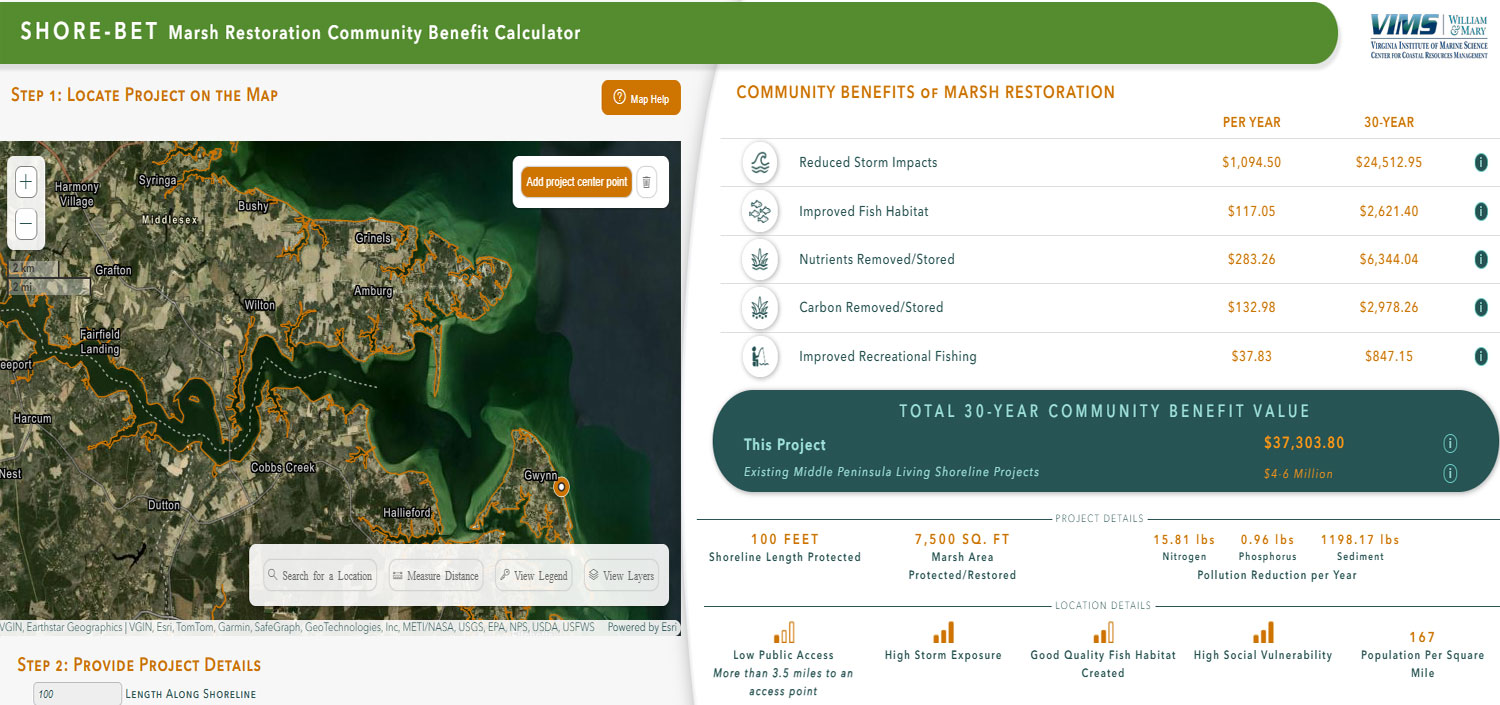
SHORE-BET estimated that my proposed small project would generate about $37,300 in community benefits over a 30-year period. The benefits were led mostly by reduced storm impacts, with additional gains tied to fish habitat, nutrient storage, carbon storage and recreational fishing.
That number was not enormous, and that was actually reassuring. It suggested that even a small project can produce measurable value without the tool having to exaggerate the case. The calculator also let me see some of the conditions shaping that estimate, including high storm exposure, low public access, high social vulnerability and a population density of 167 people per square mile. Moving the project to other areas produced slightly different results depending on conditions, population, habitat and public access. That makes it possible to experiment and see where small projects might have the greatest impact.
The ability to perform hands-on testing is part of what makes the tool feel useful rather than theoretical. It does not just celebrate restoration in broad terms. It breaks the potential value into categories that a planner, grant writer or local official could actually discuss. In the case of my little test project, reduced storm impacts accounted for the biggest share of the projected value, followed by smaller but still meaningful returns tied to nutrient removal, fish habitat, carbon storage and recreational fishing. That kind of breakdown helps explain why a project may be worthwhile even when the total does not look dramatic at first glance.
NOAA’s description of the new tool highlights that same idea. As VIMS associate professor Andrew Scheld put it, “Shoreline management decisions can have important impacts on communities in the region, such as supporting recreation and protecting property. By translating those benefits into dollars, it helps us better understand tradeoffs and make informed management decisions.”
That may be the best way to think about SHORE-BET. It’s not a flashy climate-tech dashboard, and it isn’t trying to settle every policy argument. It is a quieter kind of government-backed tool, one that helps make a category of environmental work easier to evaluate in practical terms. NOAA says the calculator can estimate benefits from reduced storm impacts, improved fish habitat and carbon removed or stored as part of the projected benefit mix.
The broader numbers help explain why that matters. NOAA says a recent VIMS study estimated that marshes and living shorelines provide roughly $90 million in annual benefits to local communities in Virginia’s Middle Peninsula, with reduced storm damage representing the largest share. The VIMS FAQ adds an important note of restraint: SHORE-BET likely underestimates the full value of marshes and living shorelines because it does not capture every use and non-use benefit. In other words, even this attempt to put restoration into dollars does not tell the whole story and could never track every local benefit.
That would certainly be true of my modest efforts to help out down in Calvert County. Over time, it was clear to see that our efforts were improving conditions in the local area. For one, we started to notice more little feeder fish in the area, an important part of the ecosystem and an anchor for the lower part of the food chain. Later on, two turtles moved in and appeared to make the area their new permanent home. Finally, when a huge coastal storm hit the area, I drove back down to the project area expecting to find devastation, but the plants had taken hold, and the shoreline looked relatively stable. A few hundred feet away from the project area, there were clear signs of erosion, plus none of the telltale signs of wildlife habitats.
So, I felt pretty good that our little project was making a difference, but we never had any way of knowing how it might also be improving the surrounding area or the Chesapeake Bay ecosystem in general. A shoreline project can involve lots of volunteers planting marsh grass, hauling away debris and watching for wildlife returning to an area. But from the ground, it can seem like a small and local effort. SHORE-BET does not change that. What it does is widen the lens, giving communities a way to see how those small projects can translate into stronger habitats, better water quality and a degree of protection that adds up over time.
John Breeden II is an award-winning journalist and reviewer with over 20 years of experience covering technology. He is the CEO of the Tech Writers Bureau, a group that creates technological thought leadership content for organizations of all sizes. Twitter: @LabGuys