How to Help Mars Robots With Their Missions
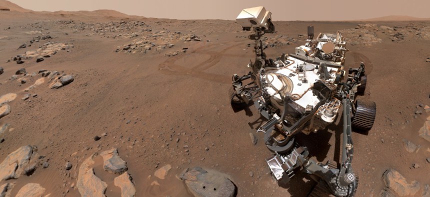
NASA’s Perseverance Mars rover took this selfie over a rock nicknamed “Rochette,” on September 10. NASA


NASA would like everyone to pitch in.
This weekend I spent quite a bit of time helping Mars rovers learn how to avoid various mission-killing traps like the large rock fields and deep sand pits that are spread out all across the surface of the red planet. And NASA would like everyone to pitch in and assist the 12,000 of us who have already joined that effort.
Historically, the Mars rovers have performed extremely well. Most of them launched with anticipated mission windows spanning just a few weeks or months, but lasted for years in that very harsh environment. However, the perils of Mars are myriad. In addition to things like extremely cold temperatures, radiation and violent dust storms, even the landscape of Mars can swallow up an unwary rover. That is what happened to Spirit. Launched in 2003 on a 90-day mission, it survived for seven years while exploring the unknown parts of Mars. It was finally done in by the same thing that often wrecks my golf game, a deep sand pit that it accidentally wandered into.
The scientists at NASA’s Jet Propulsion Laboratory would like to avoid losing future rovers to those kinds of traps. And to do that, they need to teach the little robots how to recognize and avoid the kind of terrain that can permanently end their roving. They would like to accomplish that using machine learning technologies and algorithms which are not too different from what empowers self-driving cars back on Earth. But instead of scanning for stop signs and wandering pedestrians, the rovers are mostly concerned with what’s under their wheels.
But NASA has millions of pictures and video frames of the Martian landscape taken by various rovers over the years. The trick is taking all those pictures and turning them into data that will help the robots identify what they are seeing. And that requires human ingenuity, which is where I, along with 12,000 others so far, are helping out.
NASA originally started with a subset of about 1,000 images as a proof of concept. Admittedly, the sample size was a little small, so the first SPOC (Soil Property and Object Classification) algorithm only achieved about a 40% accuracy rate. But after shifting the categories a little bit and adding 100,000 more images, the accuracy shot up to 91.41% for version two. Now, NASA would like to improve that even further, and everyone is invited to help out.
To improve the accuracy of the algorithm, NASA is asking for help from the public. This kind of crowd sourcing has been wildly successful in the past with everything from fighting disease and designing medicine to helping find cost savings and solving other problems at federal agencies. So the idea behind enlisting the public’s help for important projects is a sound one. And as a bonus, NASA has made its new project pretty fun.
The AI4Mars project tasks volunteers to look at sometimes stunning images of Mars taken from various rover missions and identify the types of rocks and soil found there. It’s almost like one of those hidden object type games which are so popular on mobile phones these days.
How you “play” the AI4Mars project is by selecting one of the terrain types listed along the side of the screen. They include different soils like those embedded with bedrock, pebbles, veins, hills and float rocks. And of course it also includes finding dangerous patches of sand. When you click on a terrain type on the side of the page, the cursor will change color to match it. You then must outline the type of terrain that you are identifying. Some of the major terrain groups have subtypes that you should also identify. There is a tutorial that shows you how to do everything which you can bring up at any time if you get stuck or can’t identify something.
Every piece of classified terrain will help to tune the SPOC algorithm and teach future rovers how to safely navigate around Mars. That said, there are a few terrain types that NASA is most interested in classifying. This includes tall rocks over 30 centimeters in height, because they are relatively rare in the photos. So if you find one, it’s kind of a big deal. And, of course, NASA also really wants to identify sand so that rovers don’t fall into mission-ending traps like Spirit did.
The new project is 28% complete, so there is still lots of work to do and much help needed. If you have a good eye for rocks and want to help future Mars missions, NASA would love it if you could join me and the other volunteers in helping to make an alien environment a little safer for our intrepid robot explorers.
John Breeden II is an award-winning journalist and reviewer with over 20 years of experience covering technology. He is the CEO of the Tech Writers Bureau, a group that creates technological thought leadership content for organizations of all sizes. Twitter: @LabGuys
NEXT STORY: You Know How to Identify Phishing Emails