NASA data aids Nepal earthquake recovery


Multiple NASA offices are involved in an effort to upload large amounts of data to a country where Internet bandwidth is limited.
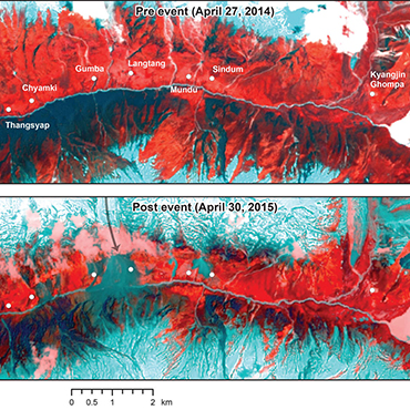
NASA's Landsat 8 reveals the Gorkha earthquake's extent within Nepal's Langtang Valley.
NASA is compiling and coordinating satellite imaging data and sending portable ground-based imaging technologies to rescuers in Nepal sifting through the devastation from the massive April 25 earthquake.
The 7.8 temblor in the Himalayan nation, dubbed the "Gorkha earthquake," has claimed thousands of lives with building collapses, avalanches and other associated calamities. NASA said it is supplying optical and radar satellite data pulled from a number of domestic and international partners and compiling them into a variety of data "products" such as vulnerability maps and damage proxy maps that can tag danger zones and determine the extent of existing damage in other areas.
In addition to the imaging data, NASA said it has also dispatched a new ground-based portable radar sensor called FINDER (Finding Individuals for Disaster and Emergency Response), that can locate people buried as deep as 30 feet below crushed materials and 20 feet below solid concrete, based on their heartbeats and breathing patterns. The technology was developed by the Department of Homeland Security's Science and Technology Directorate. .
The data gathered by satellite will be used to create risk models and assess infrastructure damage. The data can also be used to see into remote areas where landslides, river damming and avalanches might complicate recovery efforts.
NASA noted the challenge of getting satellite data to Nepalese government officials in a country where Internet bandwidth is limited. It’s a coast-to-coast and around the world effort.
NASA-USAID SERVIR, an initiative that integrates satellite observations, ground-based data and forecast models to monitor and forecast environmental changes and to improve response to natural disasters, is working through the SERVIR-Himalayan office in Kathmandu. The Himalayan office is supported by NASA’s Marshall Space Flight Center in Huntsville, Ala.
The NASA personnel in Huntsville are coordinating image tasking, processing, compression, and distribution efforts with the agency's Goddard Space Flight Center in Greenbelt, Md., and the Jet Propulsion Laboratory in Pasadena, Calif.
NEXT STORY: Do We Need to Add an 'A' to STEM?