State Department: Mapping the humanitarian crisis in Syria


 By
Frank Konkel
By
Frank Konkel
The department's maps can help people make sense of complex humanitarian emergencies and understand what is happening on the ground.
Although the State Department is both a producer and a consumer of geospatial data, geo-analytics and maps, not all of its work is kept behind closed doors.
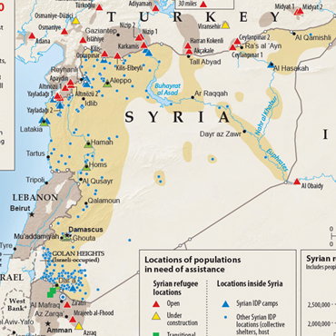
For instance, State's Humanitarian Information Unit collects, analyzes and disseminates unclassified information regarding humanitarian emergencies, and publishes high-quality maps that track relevant variables such as refugee migration and global health initiatives. The HIU team consists of roughly 20 analysts, researchers, geospatial analysts, cartographers and developers under the department's Office of the Geographer and Global Issues.
Josh Campbell, GIS architect at HIU, said the unit's maps can help people make sense of complex humanitarian emergencies and understand what is happening on the ground.
The team is known for its accuracy, and HIU's maps are widely cited by the media. But the work is intensive. In 2013, the team was particularly busy tracking the civil war in Syria. To document the migration of refugees, analysts pooled data from media reports, commercial satellite imagery and internal documents. Then subject-matter experts sifted through the data to ensure its legitimacy, technical staffers built corresponding datasets, GIS analysts compiled the data, and cartographers produced the finished products.
Some maps showed the displacement of refugees over time while others mapped the escape routes and destinations of the 1.8 million Syrian refugees, including the hot spots from which they fled, where they went and where the humanitarian resources were located. The maps gave decision-makers valuable insight into the conflict from a humanitarian standpoint.
"Maps unlock a great cognitive power," Campbell said. "Visualization, whether graphical or geographical, simplifies complex relationships."