NOAA Teams with Record-Breaking Explorer to Map the Unknowns of Earth’s Deepest Ocean Points
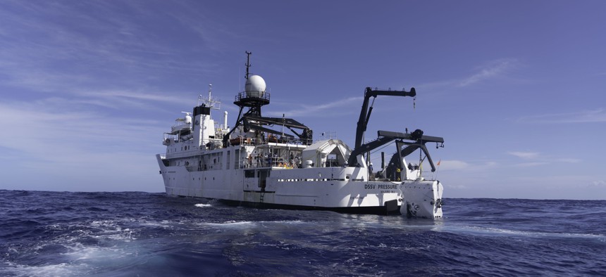
Caladan Oceanic's Deep Submersible Support Vessel Pressure Drop launches the full ocean depth submersible called Limiting Factor, from Triton Submarines. Caladan Oceanic


The agency will work with Victor Vescovo’s Caladan Oceanic to share assets, facilities and data that they hope will strategically power new discoveries.
The National Oceanic and Atmospheric Administration recently teamed up with a record-breaking explorer to survey and map unknown parts of the world’s deep oceans.
Spurred by a conversation at a White House summit in November, the agency this week signed a formal memorandum of agreement with Caladan Oceanic, LLC and it’s owner Victor Vescovo—the first person in history to ever reach the deepest point in all five of the world's named oceans, as well as the top of all of its continents and both poles.
According to the memorandum signed Monday, officials from both entities will meet regularly to discuss plans and objectives regarding relevant endeavors and also share assets, facilities and data that they hope will strategically power new discoveries in the world’s deepest waters.
NOAA’s Office of Ocean Exploration and Research Director Alan Leonardi told Nextgov Wednesday that agency insiders have always viewed exploring the ocean as a partnership endeavor.
“Ocean exploration by its nature is a multidisciplinary field of science that requires application of ships and novel technologies to fully explore and understand the ocean, from the seafloor to the surface,” he explained. “Partnerships allow us to engage the right cross-section of scientists to both understand what priorities for exploration exist and to fully document our findings.”
Leonardi added collaborating with organizations that can share access to the latest advanced technologies like Vescovo’s enables NOAA to “increase the pace, scope, and efficiency with which we explore the seafloor and water column [or the conceptual vertical expanse of water stretching between the surface and bottom sediment] allowing us to better understand their physical, biological, and chemical characteristics as well as the connections among them.” Further, the collaborations also allow the agency “to ensure that the data and samples [officials] collect are properly curated and stored in repositories” that can be accessed by anyone in their own research.
As a partner, Vescovo brings perhaps some of the most relevant deepwater exploration experience to the table. In recently conducted missions known as the Five Deeps Expedition, Vescovo voyaged in a human-occupied submersible vehicle into some of the deepest trenches of the Pacific, Atlantic, Indian, Southern and Arctic oceans, NOAA noted in its announcement. On the journey, Vescovo’s crew covered 47,000 nautical miles in 10 months. With those underwater explorations in mind, agency officials said the explorer and his company bring “to this partnership unparalleled capabilities and technologies to explore the hadal zone—the deepest, darkest and coldest region of the ocean found below 6,000 meters or 3.7 miles.”
Though the agency connected with Vescovo in 2017—when Caladan acquired a former NOAA research ship and significantly retrofitted it for his company’s own efforts—Leonardi said this new, formal collaboration emanated from discussions during a November White House summit on Partnerships in Ocean Science and Technology. At an evening event preceding the summit, Vescovo gave a keynote address and asked the government how he could support our efforts to explore the ocean.
“NOAA Leadership immediately engaged in dialogue with Mr. Vescovo and decided to enter into a formal memorandum of understanding to communicate further and decide if there were specific activities we wanted to partner on together,” Leonardi said. “That formal agreement was finalized this week and announced publicly.”
Regarding what the agency ultimately hopes to accomplish through the agreement, Leonardi said NOAA aims to broaden understanding of “our largely unknown ocean” and support the implementation of the Presidential Memorandum on Ocean Mapping of the U.S. Exclusive Economic Zone and the Shoreline and Nearshore of Alaska, which was released in November 2019. The efforts laid out in it include conducting work to fully map the U.S. Exclusive Economic Zone—or the zone where the U.S. and other coastal nations have jurisdiction over natural resources—to identify priority areas for exploration and characterization, and then to subsequently explore and characterize those priority areas.
“Completing this effort in a more timely fashion (one to two decades) will require active engagement and partnering with all sectors,” Leonardi said. “Partnerships such as the one with Caladan Oceanic are anticipated to donate data in support of government efforts, advance the technologies needed to complete the work sooner and more cost-effectively, and to raise awareness about the importance of the oceans to our health, economy and security.”