The Race to Code the Curb
Tricia Daniel/Shutterestock.com


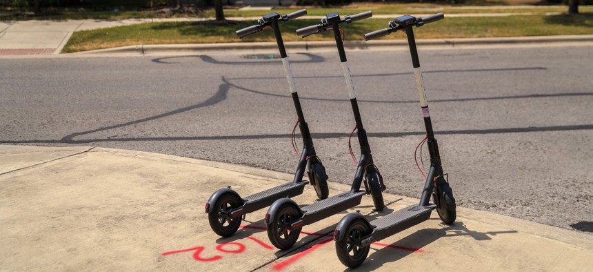
Everyone—from ride-hailing cars to delivery trucks to bikes and scooters—wants a piece of the curb. How can smart cities map and manage this precious resource?
The curb is hot. No longer just a home for parked cars and cigarette butts, this is where the action is in the 21st century city. It’s where electric scooters and bikes congregate, where delivery drivers drop off Amazon boxes, where Uber and Lyft cars scoop riders. Someday, it may be where driverless cars await their human cargo. Accordingly, this increasingly contested space has become a focus of serious attention from some of the world’s leading technology companies.
Today, a startup is announcing an open-access platform that maps points of interest where the sidewalk meets the street. Coord, a spinoff of “smart city” developer Sidewalk Labs, launched its “Open Curbs” initiative, which pins the locations of wheelchair cuts, fire hydrants, bus stops, and other physical assets that define the curb to digital maps, available to anyone who’s interested in using them.
The hope is that this tool can help curb-curious local officials, mobility companies, and researchers can reach a common understanding of the physical environment they’re all operating in. That way, rules can be equitably enforced and companies can more easily comply with them. Right now, neighborhoods in Santa Monica, Denver, Paris, Milan, L.A., and San Francisco have been mapped; other cities, including San Diego, are on the way.
“One of the reasons cities and fleets want to work with us is that they frankly struggle to get that information,” Stephen Smyth, the CEO of Coord, told CityLab. “We want to be the broadcast channel for all the regulations on using this particular land.”
Startups Flock to the Curb
The Open Curbs Initiative is one of many new data-driven curb-related products that have emerged in recent months, and not only from Coord. To manage mushrooming demand for this valuable public resource, regulators are racing to adapt to the smartphone-powered present and future of transportation. And new startups are pitching them with an array of savvy solutions.
Most cities don’t currently have digital maps that would allow them to regulate curb users in anything approaching real time. Traditionally, a local department of transportation might take an annual inventory of curb features for planning purposes, or researchers might study a block for a day or a week. Different departments may have disparate information. None of this is fast enough to keep track of the rapid changes happening at street level. The closest thing Smyth says they could find was Seattle’s annual on-street occupancy report. “We realized that curb space was relatively un-digitized,” he said.
Coord’s latest effort is free and open-access, but much of the curb data built into its maps comes from another tool that Coord markets to local governments, called Surveyor. Local governments can also publish their own survey data on it. It uses augmented reality to identify objects on the curb, such as fire hydrants, parking signs, bus shelters, and curb cuts. The result is a continual inventory of a given curb’s available features.
Apart from providing an authoritative catalogue of a city’s assets, bringing all this information together could help cities measure the revenue generation potential of their curbs—useful as cities evaluate how to shift revenue away from car parking to newer options like scooters and ride-hailing. “It's like a shopkeeper taking inventory before setting prices,” said Smyth.
A dynamic map of curb data can also be key for cities to achieve other goals, like sidewalk compliance or equitable access. Populus, a San Francisco-based transportation data company, has a platform called Mobility Manager, which gives cities access to parking data from e-scooters and e-bikes operated by private companies. Last year, Populus partnered with D.C.’s Department of Transportation to see where dockless vehicles dispersed into the District, finding fewer bikes the city’s poorest neighborhoods.
More recently, Populus has been ingesting data from LimePod, the new car-sharing service from the dockless scooter company Lime, to construct a profile of how these modes compare on the curb in Seattle. The company wants to pair that data with other, more qualitative tools, such as intercept surveys (where they talk to riders to get a sense of how human behavior affects the use of these new modes). “The interaction of many new alternatives impact people's travel choices,” said transportation researcher Regina Clewlow, co-founder and CEO of Populus. “There’s going to be a need for more data and information so cities can be more nimble in their policy and pricing.”
Private mobility services want a piece of this data mine, too. Coord’s Open Curbs Initiative is designed to work in concert with a paid product that the company sells to mobility companies—the “Curbs API”—which contains the rules and regulations that enforce curb access. For example, a taxi driver for a company that subscribes to the API can be notified via smartphone when he’s idling too long in a drop-off zone.
No wonder the venture capitalists that fueled the ride-hailing and dockless scooter booms see something in the data business, too: Companies like Populus and Coord have raised millions in recent funding rounds based on the value they could capture at the curb.
Smoothing Out the Data
These new transportation modes kick up clouds of digital exhaust. Some of that data is sensitive and traceable to riders; some comes in formats that are unreadable by other parties. In order to exchange data about what happens on the curb, companies and cities need a common language.
Some cities have done this by requiring private companies to use the current open data standards, similar to GTFS, which is the standard data format for transit and bike-sharing systems built by Google Maps. But the Los Angeles Department of Transportation has recently outlined its own Mobility Data Specification to create such a uniform language for a private feed. The city has an API that links up with the private software programs from scooter, bikeshare, and ride-hailing companies to obtain real-time trip data. This allows L.A. to understand where vehicles are distributed across the city, and to adjust and enforce regulations for private mobility companies directly through their apps.
On CityLab’s Technopolis podcast, LADOT general manager Seleta Reynolds said those standards will be the foundation for cities to eventually be able to give new mobility companies permission to access the curb. Say a user of a dockless scooter is ready to end her trip. The company’s app could send a request to the city’s digital operating system to verify an appropriate place to park. Or, from the government’s perspective, the city could intervene if it sees there aren’t enough scooters available near transit hubs, or if riders keep leaving dockless devices in a no-park zones.
Reynolds described how this approach to exchanging data between public and private entities differs from what some cities are resorting to today, which is simply asking for data without knowing exactly how they plan to use it. “Instead of poking you on the shoulder and saying, ‘Hey, can I please have your data?,’ [the city] going to be in your product workflow,” she said.
To help other cities and companies communicate about what’s happening at the curb, L.A. shared the code for its API on Github, an open-source tool for developers.
Making Sense of the Data Streams
But information isn’t useful unless it’s presented clearly. Remix, a transit data startup, offers what it calls a New Mobility tool, designed to analyze and visualize data streaming off of new transportation modes. It’s an added layer of information on top of the street management and bus network design tools Remix already offers for 300 cities worldwide. The hope is to help cities experiment with street reconfigurations that make smarter use of space, such as turning vehicle parking spots into corrals for scooters.
“The technology has finally caught up to where city planners want to be,” said Tiffany Chu, co-founder and chief operating officer of Remix. “The right data can completely change how cities are designed and how space is allocated on streets. It also tells a visual story to help make the case for any changes. In this era of new mobility, the streets of the future must change, and the status quo is not good enough.”
Third-party platforms like Remix believe they could be the middlemen handling knotty concerns about users’ privacy and companies’ trade secrets as cities push for more transparency to achieve mobility goals. But many companies are still uncomfortable with sharing data in any format, to any entity. In February, Uber’s dockless bikesharing subsidiary, Jump, pushed back on Los Angeles for the city’s requirement of fine-grained location data, citing security concerns. “The reasons given to date, such as parking enforcement, event management, and infrastructure improvement, can be addressed without resorting to real-time surveillance,” the company wrote in its letter to LADOT.
The company suggested using the open source SharedStreets platform, which uses a referencing system to aggregate trip data on a street onto shared maps that any company can use, rather than using a real-time data collection through L.A.’s API. Regulating the curb in real time not only introduces new risks to individual privacy, but could also do harm to the idea of the public street itself, Uber argued.
Kevin Webb, the co-director and co-founder of SharedStreets, agreed that whenever movement data is being gathered on large populations, the rationale needs to be clear. “It’s important to articulate the values around why cities should retain control of the public space and revenue streams rather than handing it off to a private company.”
In other words, some of the new, data-oriented products that aim to pave over conflicts at the curb are also raising new conflicts about privacy and governance of public space. In attempting to combine real-time and long-term efforts to manage the curb, cities could risk overstepping their right to surveil the action.
But given the current boom in curb activity, these are debates worth having. In a Coord press release, Hector Soliman-Valdez, the mobility manager of the Downtown Santa Monica Business Improvement District, praised the company’s efforts to help communities meet those growing demands: “Having a complete picture of the current designations of our district's curbs helps us prepare for the future that is already here.”