Helping Smart Cites Harness Big Data

jamesteohart/Shutterstock.com


The open-source mapping company Mapbox is starting a new “mentorship” program to help cities tackle their most pressing urban issues.
Harnessing the power of open data is key to developing the smart cities of the future. But not all governments have the capacity—be that funding or human capital—to collect all the necessary information and turn it into a tool. That’s where Mapbox comes in.
Mapbox offers open-source mapping platforms, and is no stranger to turning complex data into visualizations cities can use, whether it’s mapping traffic fatalities in the U.S. or the conditions of streets in Washington, D.C., during last year’s East Coast blizzard.
As part of the White House Smart Cities Initiative, which announced this week it would make more than $80 million in tech investments this year, the company is rolling out Mapbox Cities, a new “mentorship” program that, for now, will give three cities the tools and support they need to solve some of their most pressing urban challenges.
It issued a call for applications earlier this week, and responses have poured in from across the globe, says Christina Franken, who specializes in smart cities at Mapbox.
“It's very much an experimental approach to working with cities,” she says. “A lot of cities have open-data platforms but they don't really do something with the data. So we're trying to bridge that gap.”
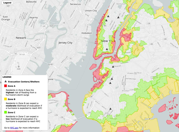
But the company isn’t approaching the project blindly. In a way, Mapbox has the necessary experience to help cities jumpstart their own projects. Its resume includes, for example, a map that visualizes the sheer quantity of traffic fatalities along any commuting route in the U.S., showcasing its ability to turn a whopping five years’ worth of data into a public-safety tool. During 2012’s Hurricane Sandy, Mapbox created a disaster-relief tool to help New Yorkers find shelter.
And that’s just in the United States. Mapbox recently also started a group focusing primarily on humanitarian issues and bringing its mapping and data-collecting tools to aid organizations all over the world in times of crisis. It provides free access to its vast collection of resources, and works closely with collaborators to help them customize maps based on specific needs.
“We're doing something similar without the need for an emergency,” says Mikel Maron, who helps government and humanitarian organizations make use of OpenStreetMap (a collaborative mapmaking platform). “Let's find cities where we can really develop an in-depth relationship, understanding what they’re trying to achieve. And can we go even further, in terms of providing ideas and solution, than what they were thinking themselves?”
There are still so many urban challenges the company hasn’t tackled yet but has the tools to do so, Franken says, including those related to infrastructure, neighborhood relationships, and identifying unintentional biases in the transport system.
For the cities initiative, the company wants the three cities it works in to be diverse in their locations, size, issues and experience in working with open data. How the partnerships will play out depends on what challenges, resources and dynamics city governments bring to the table.
“We’re keeping it very open,” she adds, “because we want to learn.”
NEXT STORY: Body Cameras Are Betraying Their Promise