Radar Satellites Spying on Farms From Space Is a Taste of the Future Economy
ICEYE/Quartz


 By
Tim Fernholz
By
Tim Fernholz
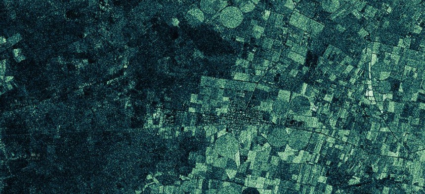
Images are created by synthetic aperture radar can 'see' through clouds.
The images below, created by a radar satellite built and operated by a private company, are a taste of a future in which anyone can purchase the ability to monitor changes on Earth from space.
ICEYE, a company in Finland, shared these exclusive radar images with Quartz to demonstrate the capabilities of a satellite it launched into an orbit 500 kilometers above the planet in January.
In the two animations, you can see how agricultural fields outside of Havana, Cuba, reshaped between January and February 2018, reflecting changes in irrigation and harvests:

It’s not an accident that ICEYE shared imagery of Cuba, where the agricultural sector is opaque and under stress. “When you have a satellite, you want to demonstrate that you can take pictures of places you wouldn’t otherwise image,” Pekka Laurila, the company’s co-founder, said.

Technology that sees through clouds
The images are created by synthetic aperture radar, which bounces radio signals off the ground and detects their reflections, using computer models to construct images of the shape of things below. Its principal advantage over passive imagery is that it can peer through clouds, a key obstacle to imaging on a planet with a lot of water on it.
ICEYE shares the goal of potential competitors like Planet, which images the entire landmass of Earth daily: They want to speed up the commercial space-sensing industry, providing updates on ground activities frequently enough to see what is changing and how. Laurila wants to give his clients the ability to check in with a specific place every three hours.
That will have to wait until ICEYE has a full fleet of 20 satellites, perhaps by 2020. Later this year, it expects to launch two more demonstration satellites. ICEYE is working with the European Space Agency and has received investment from the U.S. Defense Department, which sees cheap radar satellites as vital to gaining advanced warning of enemy missile launches.
The challenge of a new kind of instrument
The company expects to provide not just agricultural data, but information about the environment, climate change, transportation and energy infrastructure, natural disasters and maritime activities.
The technological challenges remain daunting; this demonstration model of the satellite can only snap a few pictures an hour. Because radar requires transmitting signals to Earth and detecting their reflections, the satellite uses more power and a larger antennae than imaging satellites: Its mass is 70 kilograms, compared to Planet’s Dove imaging satellite at less than 10 kg. But traditional radar satellites weigh many tons, and are far more costly than the several million dollars the company needed to build their first spacecraft.
“We started with resistor-level components building this instrument and this satellite,” Laurila says. “This kind of instrument didn’t exist in the world and we needed one for our business case.”