A Startup’s Constellation of Tiny Satellites is Now Photographing Half of Earth’s Landmass Every Day
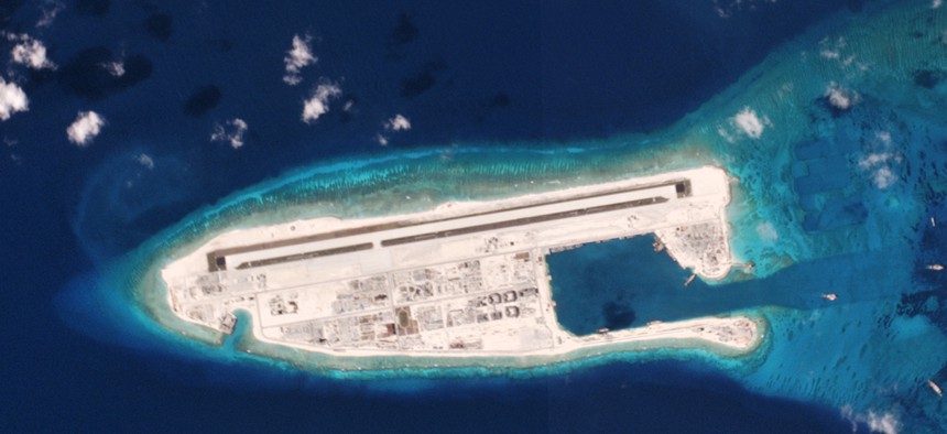
A satellite image of a Chinese military installation on Fiery Cross reef in the South Pacific on 5/1/16. Planet Labs


 By
Tim Fernholz
By
Tim Fernholz
Are you ready for the coming era of global transparency?
Are you ready for the coming era of global transparency?
After two years in operation, the satellite-imaging startup Planet tells Quartz it is now photographing more than 50 million square kilometers of the earth every single day. That’s about a tenth of the world’s surface area, or half its landmass. Indeed, in September 2016 alone, the company says it imaged 91 percent of earth’s landmass.
Planet’s plan is to make that imagery available to the public, with free basic access and premium accounts for higher quantity and quality data. It’s likely to impact everything from finance and farming to environmental protection and human rights.
The company’s goal is “to image the whole world every day, making change visible, accessible and actionable,” Robbie Schingler, cofounder and chief strategy officer of Planet, said at the International Astronautical Congress in September.
Satellite imagery at this scale is typically available only to governments and deep-pocketed companies. But the technology Planet developed to gather this data cheaply also allows it to provide more up-to-date imagery. The commercial satellite images the public sees most commonly on services like Google Maps or Bing are often months, if not years old, and we have no sense of how they have changed.
“We have old mental models for the state of the world,” Schingler said. “The world is increasingly dynamic, and a lot of that is happening without people knowing about it.”
The technology currently used to gather these images are large, expensive satellites flying 600 kilometers or more above the earth. Their operators typically target these satellites on specific areas requested by their clients. But these satellites can’t be everywhere at once, and competition over satellite capacity drives up the cost of using them. This is further compounded by the fact there is only so much cloud-free daylight over earth for imaging.
Conversely, Planet uses lots of small, cheap satellites, flying closer to 400 or 500 kilometers above the planet. Currently, it has 63 operational satellites, and it envisions deploying a 120-satellite constellation. These satellites orbit the earth in a formation that moves like the head of a scanner, scooping up a swathe of images of the entire planet as it rotates below. This daily, bulk collection makes it possible for Planet to monitor, rather than target, satellite imagery.

In practice, this means the imagery can be used to detect changes by comparing recent data across multiple time periods. Consider some of the early adopters the company has been sharing its data with:
- Amnesty International used its imagery to track refugee camps in Syria.
- Descartes Labs is developing machine-learning technology to forecast land-use trends for farmers.
- The Monitoring of the Andean Amazon Project found illegal mining and deforestation in Peru.
- Orbital Insight used its data to count ships in seaports to provide analysis to investors.
At the International Astronautical Congress, one attendee wondered if this imagery could be used for nefarious ends. Planet’s satellites generally only capture about 3 meters of resolution per pixel, which means it’s not detailed enough to make out individual people, which might lay some privacy concerns to rest. One could also argue it’s better a relatively open, online platform hosts this imagery instead of a secretive government agency.
But looking back on history, Schingler pointed to how satellite imagery helped ameliorate one of the world’s biggest threats: nuclear annihilation. It was in part the launch of the first spy satellites by the U.S. and the Soviet Union that led to the 1972 anti-ballistic missile treaty, simply because both parties had an independent means of assessing the other’s arsenal.
“It allowed people to make better decisions and not assume the worst,” Schingler said.