Stand Up and Be Counted


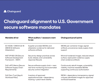
We're a little over a week into the 2010 decennial census -- most census forms were delivered between March 15 and 17 -- and it's time for a progress report, courtesy of the Census Bureau's new <a href=http://2010.census.gov/2010census/take10map/>Web mapping feature</a>.
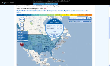
We're a little over a week into the 2010 decennial census -- most census forms were delivered between March 15 and 17 -- and it's time for a progress report, courtesy of the Census Bureau's new Web mapping feature .
The Census Bureau earlier this month launched the Take 10 map, an interactive tool that tracks the national mail participation rate, or the percentage of forms mailed back by households that received them. The public can look at participation from a national view all the way down to a local city tract view and compare their progress to the 2000 census.
As of Wednesday, the national mail participation rate was 16 percent, but state and local jurisdictions were all over the map -- literally -- in comparison. Montana currently tops the standings at 30 percent, while Florida, at just 3 percent, brings up the rear. The top 50 cities/towns are almost all located in the Midwest--Westside City and Leighton City, both in Iowa, are tied at 74 percent participation.
Rates vary significantly even within city lines. In Northwest Washington, D.C., for example, two adjoining tracts have 32 percent and 16 percent response rates, respectively. In Southeast D.C., a 6 percent tract borders a 24 percent tract.
In my own neighborhood, near Logan Circle, we have yet to receive our census forms.
NEXT STORY: USPS Takes to the Web to Explain