Ash Carter on Facebook, supercomputing at LLNL and GPS alternatives


News and notes from around the federal IT community.
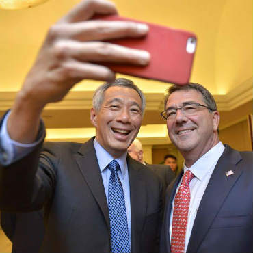
Ashton Carter, right, with Singapore Prime Minister Lee Hsien Loong, in one of Carter's first posts as Defense Secretary on Facebook.
Pentagon boss joins Facebook
Ashton Carter sought to strike a hip and welcoming tone last week by becoming the first Defense secretary to join Facebook.
"Took my first 'wefie' last night with Lee Hsien Loong before the start of the Shangri-La Dialogue in Singapore," Carter said in one of his first Facebook posts, which included a photo of himself and the Singaporean prime minister.
"Joining Facebook is just one more way [Carter] can better communicate with service members and their families and help the Pentagon think 'outside the five sided box' to drive change," the Pentagon said in a statement.
Carter met with Facebook Chief Operating Officer Sheryl Sandberg in Silicon Valley in April.
National lab getting new supercomputing facility
Lawrence Livermore National Laboratory broke ground last week on a modular supercomputing facility that will house its growing stable of high-performance computers.
After construction of the $9.875 million building is completed in a year, LLNL said the facility will provide space for its Advanced Simulation and Computing Program's unclassified high-performance computers systems. ASC is the high-performance simulation effort of the National Nuclear Security Administration's nuclear weapon stockpile stewardship program.
Computing buildings at Lawrence Livermore are aging, ranging between 10 and 60 years old, and weren't made to house high-performance systems, according to the lab. The aging buildings come with old electrical and mechanical infrastructures that need costly upgrades.
Army developing geolocation tools that don't need GPS
Army researchers are developing a pocket-size device that will give soldiers precise geolocation information even when GPS signals are unavailable, Defense Systems reports. The Warfighter Integrated Navigation System uses a variety of sensors to track a soldier's movement from a last known location, recording footsteps, speed, time, altitude and other factors to show the soldier's location on a map.
GPS remains the backbone of military geolocation, but the military wants alternatives for when the terrain, active jamming efforts or both compromise the satellite-based system.