Track Your Census Participation


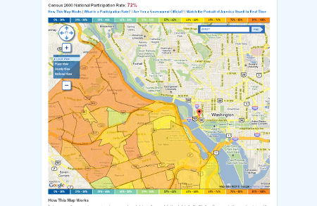
The 2010 census is fast approaching, and a friendly challenge could help boost public excitement. The Census Bureau today launched an <a href="http://2010.census.gov/2010census/take10map/" target="blank">online mapping tool</a> showing the 2000 census' participation rates across states, counties and cities.
The 2010 census is fast approaching, and a friendly challenge could help boost public excitement. The Census Bureau today launched an online mapping tool showing the 2000 census' participation rates across states, counties and cities.
The searchable, zoomable and clickable "Take 10" map, named for the 10 minutes needed to complete and return the surveys, color codes geographic areas based on mailback rates. The application will be updated when 2010 forms are distributed in March, allowing citizens to track, in real time, how their area is fairing. To increase participation, jurisdictions could see this as an opportunity for a little competition with their neighbors or simply try to best their 2000 performance.
Census also developed a toolkit , including sample Twitter and Facebook posts, to help government officials and communities spread the word about the decennial campaign.
NEXT STORY: Open Government Momentum Continues