Help Science Identify a Kajillion Astronaut Photos of Cities
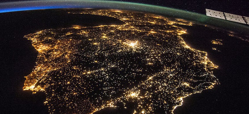
The Iberian Peninsula at night, showing Spain and Portugal. Madrid is the bright spot just above the center. NASA


"Night Cities" is an ambitious project to create an atlas of urban space photography.
Want to do a small part to help world science, or just pretend you're an astronaut ( wheee! ) zooming above Earth at 17,500 mph? Then pound some Tang and head on over to " Cities at Night ," an ambitious crowdsourcing effort to sift through an immense mountain of photos shot from space.
Astronauts have been wielding cameras since the 1960s; you can find the 1.8 million images they've captured at the Gateway to Astronaut Photography of Earth . But there's a problem: Though the photos are beautiful and crisp, especially since the 2012 advent of a high-tech tripod that adjusts for earth's rotation and the International Space Station's incredible speed, many lack georeferenced data. That creates a stumbling block to anybody in science, the media, or the general public trying to work with space-based imagery of the world's cities.
To build a comprehensive, searchable atlas of space photography , researchers at the Complutense University of Madrid are turning to the power of the crowd. They've created a bunch of different tasks that people can help out on: Dark Skies , for instance, is an easy project to differentiate cities from other things that shine in the night sky, such as stars and the moon. Night Cities asks people to put geographic locations visible in the photos onto a map, and Lost at Night is a more-advanced exercise to identify cities within a 360-diameter circle.
The Spanish researchers hope to use the geo-tagged photos in a study on the link between light pollution and energy consumption. But a good atlas of space photography could have other benefits, too. Writes NASA :
Scientists can, for example, use colors in images to estimate the types of light sources and, thus, the energy efficiency of a particular city. Researchers could use the data to compare the lighting and the economic health of a city as well. "A clear example is comparison of Madrid and Berlin," [researcher Alejandro] Sanchez says. "Madrid is the capital of Spain, a country facing a major economic crisis. It is much brighter in astronaut images than Berlin, the capital of Germany, the country with the healthiest economy in Europe. Perhaps that is an indication that Germany more efficiently manages its resources. The images can provide evidence and data to verify that."
Other potential applications include evaluating lighting for road and public safety and correlating light pollution with effects on human health and biodiversity.
And if that doesn't sway you, the images are just plain awesome to look at. Here are a few from the archives; see if you can identify them (answers below):


One hundred map-geek points go to anyone who said Chicago, Pyongyang faintly glowing in North Korea's electric blackout, Mexico City, and the cities of the Nile Delta, with Israel and Gaza in the background.
NEXT STORY: Infographic: Nuclear Reactors, But in Miniature