PUFF, just like that Air Force predicts volcanic cloud path


 By
Bob Brewin
By
Bob Brewin
Within minutes the computer model forecast where plumes of ash were headed, giving commanders valuable information about where to establish temporary operations and route aircraft.
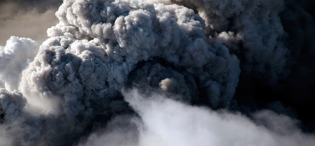 The ash from Iceland's Eyjafjallajökull volcano closed air space across Europe, affecting dozens of Air Force flights.
Shortly after a volcano in Iceland erupted on April 14 grounding thousands of flights and their passengers in Europe, Air Force weather forecasters fired up a computer model to determine how the ash plume would affect the service's air operations, delivering its first forecast within 30 minutes, a top Air Force commander said.
The forecast, developed by the 2nd Weather Squadron at Offutt Air Force Base, Neb., showed the eruption could affect flights across much of Northern Europe. The information popped up on computer screens at other commands, including those at the Air Mobility Command's 618th Tanker Airlift Control Center at Scott Air Force Base, Ill. Commanders there decided to move cargo and tanker aircraft in Germany to bases in Spain, out of the way of the expanding cloud so they could continue to conduct missions, including flights into Afghanistan and Iraq, said Capt. Justin Brockhoff, public affairs officer for the center.
Since the eruption, Eurocontrol , which coordinates air traffic across the continent, has closed much of the air space over Europe, stranding almost 7 million passengers globally. About 9,000 flights operated in Europe on Monday, down 70 percent from average, but up from about 5,000 on Sunday. A little more than two-thirds of the 300 daily transatlantic flights were able to make the trip.
To develop its quick forecasts, the 2nd Weather Squadron relied on a computer model called PUFF. Navy Lt. (jg) Dustin Hocking, a meteorologist for the squadron, layered imagery from the Defense Department, the National Oceanic and Atmospheric Administration, and European weather satellites into the application. The program used NOAA's Global Forecast System to determine the dispersion of ash across Europe.
Hocking said the squadron has updated its forecasts every three to six hours since the volcano erupted to give military air crews the most up-to-date information.
While civilian weather agencies, including the Met Office in the United Kingdom, have predicted the path of the cloud to ensure aviation safety, the Air Force develops forecasts to support mission requirements, requiring not only where the ash might spread, but also its content, which could damage aircraft, said Lt. Col. James Jones, the squadron's commander.
The job is difficult. When ash mixes with clouds, it's hard to discern the difference between water vapor and other particulate matter. "It's like pouring cream into your coffee," he said. "At first you can see the difference between the cream and the coffee, but as you stir, it all becomes a big, creamy cloud."
Jim Keane, a meteorologist with the 16th Weather Squadron, also based at Offutt, said they have relied on satellites such as those NOAA operates that have multiple spectral channels, which provide forecasters better insight than Defense satellites into the content of a volcanic cloud.
Once the PUFF model is completed, it is sent as a high-resolution graphic to Defense commands. TACC then digitally transmits the information, along with flight planning data, to aircrews worldwide.
Those receiving the updates include medvacs from Afghanistan and Iraq. Once the center realized the volcanic cloud could interfere with C-17 medevac missions at Ramstein Air Force Base, Germany, the planes, along with their medical air transport teams, were set up in Spain. Since April 16, medevac missions have flown directly from Afghanistan to Andrews Air Force Base in Washington, which require two inflight refueling operations.
NEXT STORY: Obama names his pick for U.S. public printer