The Internet Mapmakers Helping Nepal


How "crisis mappers" activate after a catastrophe
The night after the earthquake hit Nepal, people feared to sleep in their homes, worrying about powerful aftershocks toppling the few buildings left standing. They slept instead in tents, in the street or in city parks.
Meanwhile, it rained and rained. The storm soaked people’s possessions and chilled those without shelter. But it also kept Kathmandu from being seen from above—and this was more of a problem than it might seem at first.
* * *
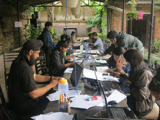
It’s become a regular occurrence: Whenever there’s a natural catastrophe, a team of “crisis mappers” activate around the world. These volunteers use crowdsourcing tools to turn satellite data into digital maps, which are then used to make decisions on the ground.
After Typhoon Haiyan struck the city of Tacloban in the Philippines, volunteers with the Humanitarian OpenStreetMap Team (HOT) worked to add the city’s pre-storm roads and buildings to the map. For months, the same group mapped the rural infrastructure of Guinea and other countries hit by the roiling Ebola crisis.
But this activation, in Nepal—many volunteers have said it is the team’s best ever.
They say they have had access to more and better imagery, earlier in the crisis, than they ever did before. And they say, too, there are simply more people volunteering.
They mention facts like this: The city of Kathmandu was already well mapped before the earthquake, but, in the past week, volunteers have tripled the amount of mapping data in Nepal in OpenStreetMap.
And all this matters. The maps that HOT makes “improve outcomes,” in the lingo of international relief organizations. In other words, they enable rescuers to deliver food, shelter, and supplies to areas that need them most. It is almost certain that they greatly help reduce suffering, and it is very likely that they save lives.
But to really understand why this activation has worked better, it’s good to return to the rain clouds.
Volunteers need pictures of Nepal from above so they can then trace them. Tracing works exactly as it sounds: People sitting at their computers see a road on an underlying image file and click-and-drag a digital version of that road on top of it. Once complete, they add that road to an online database called OpenStreetMap (OSM), where it can be calculated with like data or printed out as a map. (OSM is free to use and can be edited by anyone: It’s the Wikipedia of world maps.)
But tracing requires pictures of the ground, and pictures require satellites.
One of the world’s highest-resolution private satellites is called WorldView-3. The American company that owns it, DigitalGlobe, supplies imagery to many governments, including the United States.
Because of the thunderstorms, WorldView-3 couldn’t get a clear view of Nepal as it passed over the country on April 26. But later, orbiting above Bangladesh and about to cross the Indian Ocean, the satellite tilted backward and could see Kathmandu through the clouds. It snapped a picture.
“If you stand up, bend over, and look between your legs behind you, that’s what the satellite did,” said Kevin Bullock, a product specialist at the company.
It was the first picture of earthquake-wrecked Nepal. DigitalGlobe also open-licensed the imagery that night. By Sunday evening in North America, volunteers were already beginning to integrate the information into OSM.
Since then, many major satellite providers—including DigitalGlobe; Google’s satellite company, Skybox; the California-based startup Planet Labs; and the large European contractor Astrium—have released imagery of the affected area.
This is both a victory of technology and a victory of organization. The last time there was a major natural disaster and accompanying HOT activation, imagery was captured but could not be used on the ground for some time. Companies were not prepared to license their data openly.
“With Haiyan, it took several days,” says Bullock. “It wasn’t fast enough.”
Dale Kunce, a geographic information specialist with the American Red Cross, said that HOT, imagery providers, mapping companies and the U.S. State Department’s Humanitarian Information Unit were all much better organized and familiar with each other than they had been 18 months ago.
When the earthquake struck, he told me, “instantaneously we started getting offers, or being told that imagery was going to be made available.”
* * *
Kunce said that Red Cross International, on the ground in Nepal, is using OSM data for “literally the full gamut of what you can do with [geographic information systems] right now”: population graphs, estimates of damage, and plain old road maps.
“It’s everything from, ‘Hey, I need a map of this small area,’ to ‘I need a map of the region that shows Delhi and China and Kathmandu, because we need to figure out if we should start driving cars in,’” said Kunce.
“We sent her with a bunch of big maps that are being drawn on and sketched on, but she said last night that the printer hadn’t stopped printing,” Kunce said of the Red Cross International’s specialist on the ground.
The humanitarians have been helped by an organization on the ground already versed in OpenStreetMap called Kathmandu Living Labs. The Living Labs team was one of many that had been preparing for a big quake in Nepal for a while, and they had already mapped most of Kathmandu. (They were also funded by the World Bank.)
“They have a much better understanding of what is actually happening on the ground,” said Kunce. “They’ve been able to help us be 24 hours, so when people go to sleep in Washington, D.C., they’re up and helping to do feeds and intake.”
Kathmandu Living Labs also already has relationships with the Nepalese police and military and was coordinating their requests for maps and imagery. Both men also praised the influx of new volunteers with OpenStreetMap.
“There are literally thousands of new mappers who I’ve never met before, and they’re by and large doing a great job,” said Kunce.
DigitalGlobe has also seen the most contributors ever—more than 30,000—for a natural disaster on its crowdsourcing platform, called Tomnod. Bullock cautioned that that number still pales to the number of people who used Tomnod to look for Malaysian Airlines Flight 370 last spring. More than 8 million people hunted for the plane.
“It tears me apart because we had huge engagement and celebrities were talking about it, like Courtney Love, and we never found the damn plane,” he said. “We didn’t know where to look, we were looking in all the wrong areas.”
“And the irony is in Kathmandu and Nepal, we know exactly where to look. So we can act on those—we have actionable imagery to make a changed outcome in Nepal,” he told me.
Both men also agreed that there was a continued need for volunteers. Both OpenStreetMap and DigitalGlobe’s service, Tomnod, could use crowdsourcing help, and neither service is hard to learn. (The developer Peter Richardson’s tutorial is particularly good at teaching new users how to aid with OSM.)
I marvel every time I write about OpenStreetMap’s humanitarian team. They epitomize the the power of observation plus attention. While some of the components involved in their work are technically complex, none are particularly difficult to understand.
There’s the fleet of satellites—cameras pointing down at the Earth. There’s OpenStreetMap itself—a feat of database programming, perhaps, but also just a map. There’s the tracing software that lets individuals translate pictures into points. And then there’s the Internet, for all its flaws, linking these not-very-large networks of people and tools together, so they they may help other people who are sometimes in the same neighborhood ... and sometimes on the other side of the planet.
NEXT STORY: Delivering on the promise of big data