A New, Democratic Tool for Mapping City Streets

2seven9/Shutterstock.com


SharedStreets offers an open-source solution to help taxis, buses, pedestrians, bikers, and ride-sharing services coexist curbside.
Let’s say you’re throwing a block party. You and your neighbor both draw your own maps of where the street will be closed, and how to get there.
How would you do it? Just label some points on a line, or draw all the intersections? Do you indicate nearby parking spots? Does your map look exactly like your neighbor’s? Would partygoers looking at both get confused?
Now take that concept to the city level, where mismatched maps can have truly high stakes.
Using giant GIS databases, cities from Boston to San Diego maintain master street maps to guide their transportation and safety decisions. But there’s no standard format for that data. Where are the intersections? How long are the curbs? Where’s the median? It varies from city to city, and map to map.
That’s a problem as more private transportation services flood the roads. If a city needs to communicate street closures or parking regulations to Uber drivers, or Google Maps users, or new dockless bike-sharing services—which all use proprietary digital maps of their own—any confusion could mean the difference between smooth traffic and carpocalypse.
And, perhaps more importantly, it goes the other way too: Cities struggle to obtain and translate the trip data they get from private companies (if they can get their hands on it, which isn’t always the case) when their map formats don’t match up.
A team of street-design and transportation-data experts believes it has a solution. On Thursday, the National Association of City Transportation Officials and the nonprofit Open Transport Partnership launched a new open data standard and digital platform for mapping and sharing city streets. It might sound wonky, but the implications are big: SharedStreets brings public agencies, private companies, and civic hackers onto the same page, with the collective goal of creating safer, more efficient, and democratic transportation networks.
“Up to now, we haven’t even had the language to describe the street,” says Janette Sadik-Khan, the former transportation commissioner for New York City and the chair of NACTO’s board of directors. “This is a first down payment on building a new digital commons for the street.”
As a data standard and tool, SharedStreets helps cities translate street maps into street segments, based on how they’re chopped apart by intersections. It draws in a city or company’s existing GIS information, breaks down the road network, and spits it back out in a simplified, machine-readable format.
Then, using a digital mapping platform, cities can upload all kinds of location-based information—think traffic flows, ride-hailing pickups, crash incidents, red-light tickets—on top of that base map. The idea is, once it’s attached to a map that anyone can read, that data can be more meaningfully shared and wielded by decision makers. Using street segments as a basic common grammar allows cities to get precise about where and why they are, say, plotting taxi stands, designating bus lanes, or charging more for parking.
SharedStreets also anonymizes and aggregates all of that information, removing rider and driver information as well as the names of specific companies that provided trips. It builds a neutral clearinghouse of open-source data any city, private party, or researcher can access, upload to, and use.
“What GTFS does for transit, we’re doing for streets,” says Kevin Webb, the cofounder and director of the Open Transport Partnership and the chief architect of SharedStreets, referring to the General Transit Feed Specification. Developed in the mid-2000s by Google engineers, that’s the data standard that allows Google Maps, Citymapper, and every transit app under the sun to show you when your next train or bus is coming. Hundreds of agencies have now converted their schedule data into a common, open-source format. Like GTFS, SharedStreets isn’t designed for any one purpose—it’s there to support policy, research, and commercial innovation.
Cities have been clamoring for something like this for a while. Transportation-network companies, micro-transit services, and autonomous vehicles have telematic devices in virtually every car, collecting data on billions of trips every year. “Every car, and every smartphone inside, has become a data trove,” says Sadik-Khan. “Cities and practitioners have been left on the side of the road, fighting over a few scraps of that digital deluge.”
Indeed, as congestion thickens and curb space becomes contested territory, transportation leaders across the country have openly tussled with the likes of Uber and Lyft to access that data to manage a growing number of vehicles on the streets. But companies push back, fearing that sharing pickup, drop-off, route, and fare data could expose trade secrets or threaten passenger privacy. The information they do provide can be piecemeal or overbroad.
“Cities are sick of that walled-garden, black-box approach,” says Webb. By aggregating and anonymizing mobility data, and by presenting it in a common, usable format, SharedStreets is designed to make it easier for companies to share more data. “We need private companies to be investing and innovating, but also a sense of neutrality around how we describe their activities,” he says.
NACTO and the Open Transport Partnership worked with NACTO member cities and private companies to develop the platform. In the coming months, more brand names will come forward in support of the effort, NACTO officials say. Andrew Salzberg, the head of transportation policy and research at Uber, is in favor. When it comes to data sharing, “it’s about who is making the ask and how,” he says. “We think the approach [SharedStreets is] taking—working collaboratively—is good.”
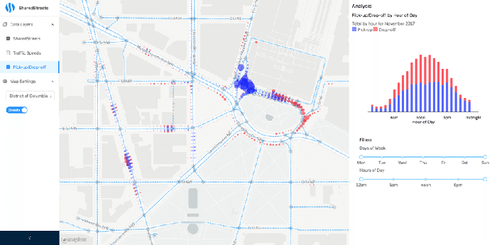
A shared, block-level view of the street could be transformative for working with colleagues inside and outside the city, says Ernest Chrappah, the director of the Department of For-Hire Vehicles in Washington, D.C. “If I’m looking at a two-block radius and I see a lot of taxi pickups or drop-offs where it says ‘no parking,’ then we can have a more useful conversation about pedestrian safety,” he says. The city might look at tightening “geofence” boundaries on where cabs can drive, and talk to ride-hailing companies to enforce theirs better.
Chrappah might also be able to communicate better with local police and colleagues at other agencies, like Sam Zimbabwe, the chief project delivery officer for Washington’s Department of Transportation. Zimbabwe foresees a range of applications for SharedStreets in his work, which lately focuses a fair amount on the shared, dockless bikes now tooling around the District. “Once you don’t have a dock-based system, it becomes much more important where exactly those bikes are being left, and the intensity of curb use,” he says. For setting up bike parking and managing rules of play, a common map could help get him and new companies onto the same page.
This isn’t an entirely new concept—similar data-sharing platforms are launching up from the likes of Sidewalk Labs and HERE Maps. But SharedStreets is different: “We have a potential solution where a middleman is not the government and not beholden only to private interests,” Chrappah says. Plus, it’s free.
SharedStreets doesn’t solve every problem. Experts have called on cities to rethink their streets as valuable resources, with curbside access as a precious commodity that’s currently being given away practically free. To keep streets open, accessible, and flowing—for pedestrians, cyclists, bus riders, Uber drivers, wheelchair users, babies in strollers—there’s a long road ahead.
But now, at least, there’s a single map that everyone can use—and a common language to read it.