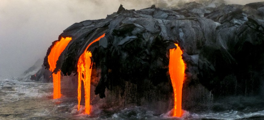
The Scary State of Volcano Monitoring in the United States
Benny Marty/Shutterstock.com


One of the most volcanically active countries in the world is not ready for a devastating eruption.
Thirteen days before Christmas, somewhere in the frigid waters of the Bering Sea, a massive volcano unexpectedly rumbled back to life.
Just like that, Bogoslof volcano began its first continuous eruption since 1992, belching great plumes of ash tens of thousands of feet into the cold sky over the Aleutian islands, generating volcanic lightning, and disrupting air travel—though not much else.
The volcano is on a tiny island about 60 miles west of Unalaska, which is the largest city in the Aleutians. It has a population of about 5,000 people.
Bogoslof hasn’t quieted yet. One explosion, in early January, sent ash 33,000 feet into the air. Weeks later, another eruption lasted for hours, eventually sprinkling enough ash on the nearby city to collect on car windshields and dust the snow-white ground with a sulfurous layer of gray. Over the course of two months, Bogoslof’s intermittent eruptions have caused the island to triple in size so far, as fragments of rock and ash continue to pile atop one another.
Geologists don’t know how long the eruption will last. In 1992, the activity at Bogoslof began and ended within weeks. But more than a century ago, it erupted continuously for years. In the 1880s, volcano observers in the Aleutians had little but their own senses to track what was happening. Today, scientists use satellite data and thermal imagery to watch Bogoslof—signs of elevated temperatures in satellite data indicate that lava has bubbled to the surface, for example. But monitoring efforts are nowhere near what they could be. For the relatively remote Bogoslof, the absence of ground-level sensors is inconvenient, perhaps, but not necessarily alarming. Elsewhere, the dearth of volcano sensors poses a deadly problem.
There are at least 169 active volcanoes in the United States, 55 of which are believed to pose a high or very high threat to people, according to a 2005 U.S. Geological Survey report.
About one-third of the active volcanoes in the U.S. have erupted—some of them repeatedly—within the past two centuries. Volcanoes aren’t just dangerous because of their fiery lava. In 1986, volcanic gas killed more than 1,700 people in Cameroon. And one of the latest theories about the epic eruption at Pompeii, in 79 A.D., is that many people died from head injuries they sustained when boulders rained down on them.
Hawaii’s Kilauea, Washington’s Mt. St. Helens, and Wyoming’s Yellowstone all have extensive monitoring. But many volcanoes in the Cascades have only a couple of far-field sensors, several geologists told me. The Pacific Northwest, which includes high-population areas in close proximity to active volcanoes, is of particular concern for public safety.
“Most people in the U.S. perceive volcanic eruptions as rare, and [believe] that we’d be able to get advance notice because of the advance in science and instrumentation,” said Estelle Chaussard, an assistant professor of geophysics and volcanology at the State University of New York at Buffalo. “However, the massive eruption of Mount St. Helens, in Washington, was only 37 years ago, and it took until the volcano became active again in 2004 to start a truly comprehensive monitoring. ... This kind of assumption is therefore very dangerous, because most of our volcanoes are not as intensively monitored as we think they are or as they should be.”
Almost half of the active volcanoes in the country don’t have adequate seismometers—tools used to track the earthquakes that often occur during volcanic eruptions. And even at the sites that do have seismometers, many instruments—selected because they are cheaper and consume less power—are unable to take a complete record of the ground shaking around an eruption, meaning “the full amplitude of a seismogram may be ‘clipped’ during recording, rendering the data less useful for in-depth analyses,” according to a 2009 report by the U.S. Geological Survey.
“Using satellite radar and other systems, it should be possible to systematically keep a close eye on most all hazardous volcanoes around the world,” said Roland Bürgmann, a professor of planetary science at the University of California at Berkeley. “Currently, some volcanoes in the U.S. and globally are well-monitored, but most are not.”
GPS helps fill in some of the gaps. As magma accumulates at the Earth’s surface, the ground bulges upward—and that bulge can be measured from space, using radar bounced off the ground. “That’s a big advance, because you don’t need sensors on the ground and, in theory, you could monitor all the Earth’s volcanoes,” said Paul Segall, a professor of geophysics at Stanford University. “The trouble is, there’s nothing up there that is designed to do that, and the orbital repeat times aren’t frequent enough to do a really good job.”
“In my view,” he added, “We haven’t even gotten up to bare bones, let alone more sophisticated monitoring.”
That’s part of why a trio of U.S. senators is reintroducing legislation aimed at improving the country’s volcano monitoring efforts. “For the past 34 years, we have experienced first-hand the threat of volcanic activity to our daily lives with the ongoing eruption at Kilauea,” Senator Mazie Hirono, a Democrat from Hawaii, said in a statement about the bill. “As recently as 2014, we had evacuations and damage to critical infrastructure and residences.”
The Hawaiian Volcano Observatory, on Hawaii’s Big Island, has been monitoring volcanoes since 1912—nearly four decades before Hawaii became a state. Today it’s considered one of the world’s leading observatories. Yet there’s little coordination between even the best observatories in the United States. The Senate bill calls for the creation of a Volcano Watch Office that will provide continuous “situational awareness of all active volcanoes in the U.S. and its territories,” and act as a clearinghouse for the reams of volcanic data that new sensor systems would collect.“Long-records of activity are especially important in volcano monitoring to successfully identify behaviors that differ from the ordinary,” Chaussard told me in an email, “and not all of our volcanoes have such records.”
“Essentially everything we do now is empirical,” Segall told me, “but most of the really dangerous volcanoes haven’t erupted in modern instrumental times.”
More data means a better opportunity to identify eruption warning signs, which Segall hopes could eventually make it possible to forecast volcanic activity the way we can predict severe weather like hurricanes. “I don’t know if it’s possible, but it seems a worthy goal,” he said. “We obviously have less ability to peer into the Earth as we do to peer into the sky.”